SkEyesBox
Configuration
The SkEyesBox is a real time mapping system which can generate 3D point clouds representing the surroundings in absolute global coordinates. It does this by precisely keeping track of where it is while sensing distance to the surrounding objects using a laser. Knowing from where and from which direction it observed an object, it can then resolve the object's global location.
The SkEyesBox is made up of a high precision GPS/INS state estimator which is closely synchronized with a custom-built laser rangefinder. The rangefinder has scanning mirror which generates a single scan-line orthogonal to the direction of travel.
The laser rangefinder measurement rate is 100,000 samples/s (100KHz) and the mirror rotation rate is 20-30Hz.
The point-cloud density depends on mapping speed. Faster flight reduces the map resolution while covering a larger area.
User Interface
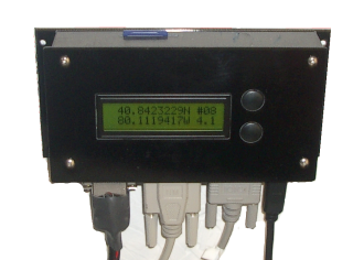
The SkEyesBox user interface is quite simple. It has a power switch, an LCD display with two buttons (UP and DOWN), and a compactFlash card slot with an activity light indicator. To use the system:
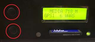
- Place the system on the ground at a suitable place to flyく
- Turn on the power switch and wait for start-up (about 30 seconds)
- After start-up, press the UP button and wait for INS alignment (leave undisturbed for about 2 minutes)
- Press the UP button to start the scan
- Press the DOWN button to stop the scan
Data from the scan is recorded on the compactFlash card.
The system can also be operated remotely using WIFI and/or wireless modem after start-up.
Real-Time Mode
The SkEyesBox can generate geo-registered point clouds in real time. The system keeps track of
its global position and orientation during flight and transforms range measurements from objects
to their absolute global coordinates during flight. The measurements are recorded to form a map
which is available on the compactFlash card immediately after completion of the flight. However,
the data is also available for use during the flight. For instance, the system can keep track of the
distance to the ground or other obstacles can can perform Nap-of-the-earth flight during data collection.
The real time mode, however, requires RTK-GPS differential corrections which need to be sent via radio communication.
The system uses a 19200 bps radio modem for differential correction.
If a WIFI connection is avaiable, a subset of the data is sent to the ground and can be viewed during collection via
a system called real-time point link. This system effectively builds and displays a 3D digital elevation map during flight.
Post-Processing Mode
Post-Processing or standalone mode is when the system operates without ground communication. The on-board
state relies on GPS single-ended mode and the GPSINS accuracy is within a few meters. The accuracy, however,
can be improved to a level better than the real-time mode after post-processing the flight data. In fact, the real-time
data is usually post processed to improve precision and accuracy.
The post-processing tools included with the SkEyesBox can use dual frequency differential correction data from public
based stations or one setup by the user at a known location.
Specifications
Please download the PDF files below:
- SkEyesBox Spec sheet SkEyesBox.pdf 377K
- Operational block diagram skbox_block.pdf 92K
Measurement data example
Options
skGCS
skGCS is a small ground control devices that manages communication with the SkEyesBox through
a radio modem that is connected to a GPS base station and a PC. It carries out the ground post-processing
GPS logs and provides the user interface to the SkEyesBox on the ground. The system can be operated
using skGCS without the need for any additional hardware.
If a PC is avaible, a suite of programs communicate with skGCS to monitor SkEyesBox status and send control commands to
the SkEyesBox mapper as well as the auto-pilot, if present.
Colorizer
The colorizer uses a camera connected to the SkEyesBox to add color information to each laser sample. The system uses a FireWire camera or a Nikon SLR digital camera. The FireWire camera can be built in the SkEyesBox enclosure and images are recorded on the compactFlash card with high precision state and time tags. If an external Nikon SLR is used, the SkEyesBox triggers the camera and sends high-precision NMEA format image time stamp to the camera.
Auto-Pilot
The SkEyesBox can be equipped with an Auto-Pilot for unmanned helicopters. The Auto-Pilot integrates information from the
GPS/INS state estimator and laser range to autonomously fly the helicopter using on-board flight controls.
Ground Station softwrae skFMS plans paths that follow desired waypoints and target
speeds the user can input graphically using a PC. The system communicates with the SkEyesBox through a radio modem or
WIFI as managed by skGCS. If ground communication is interrupted, the system returns to the take-off point through paths it
had previously followed.